What changed at Broad & Oregon in South Philadelphia?
Broad & Oregon remains one of South Philadelphia’s most recognizable intersections, but increased transit use, charter school traffic, bus route convergence, and commuter volume have dramatically changed how people move through the area. While the physical footprint remains largely unchanged, the intersection now experiences significantly higher pedestrian and vehicle activity than in previous decades.
Broad & Oregon South Philly is a vibrant intersection with a rich history. Broad & Oregon South Philadelphia has transformed from a walkable, neighborhood-centered retail intersection into a dense convergence of subway access, bus routes, charter school traffic, and through-vehicle flow. While the buildings remain largely within the same footprint between Shunk Street, Bigler Street, and 15th Street, the intensity of daily use has increased dramatically—reshaping pedestrian patterns, congestion levels, and safety dynamics.
Broad & Oregon South Philly is one of those intersections that didn’t change its footprint — but changed everything about how people move through it.
Key Takeaways
- The physical footprint of Broad & Oregon has not expanded — but the volume of use has.
- Food Fair, Acme, the State Store, and neighborhood retail once served primarily walking residents.
- The Broad Street Line station at Oregon has entrances only on the east side of Broad Street.
- West-side pedestrians must cross Broad Street to access the subway.
- Charter schools now draw students citywide, increasing drop-off and pick-up congestion.
- Moyamensing’s angled cut-through amplifies turning conflicts at Oregon Avenue.
- Bus routes layered onto Oregon Avenue create stacking, braking, and sightline challenges.
- Increased density raises pedestrian and vehicle interaction risk.
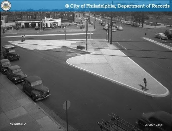
The Intersection as It Once Was
Between Shunk Street and Bigler Street, stretching toward 15th Street, Broad & Oregon functioned as a neighborhood crossroads.
You had:
- Food Fair — no parking lot, because neighbors walked.
- The Pennsylvania State Store
- The church at Broad & Moyamensing
- Acme at 15th & Moyamensing
- Harry’s on 15th & Oregon, where you weighed potato chips and pretzels from large tins.
- Dougherty’s Garage, spanning Rosewood Street to Carlisle Street on Oregon.
- The gas station at the triangle of 15th and the crossroads of Oregon and Moyamensing.
- Marconi Plaza (“The Park”), a full square block from Broad to 15th.
There was even a horse trough fountain with three spouts for police horses.
It was active — but it was local.
You shopped where you lived.
You went to school where you lived.
You picked up the C bus at Broad & Shunk.
There was movement — but not convergence.
What Changed Without Changing
Broad & Oregon did not become Center City.
No widened roads.
No high-rise towers.
No expanded street grid.
The buildings remain largely in the same footprint.
What changed is intensity of use.
- Local grocery becomes performing arts charter school.
- Subway expansion brings concentrated pedestrian flow
- Bus routes intersect Oregon as a major east-west artery
- Citywide student draw increases daily vehicle stacking.
The geometry stayed the same.
The volume increased.
That matters.
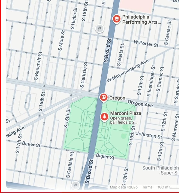
Broad Street Line at Oregon: The East-Side Access Design
At the Broad and Oregon intersection, design choices like one-sided station access shape pedestrian flow every single day.
Back when I was growing up, the northeast corner of Broad Street and Oregon Avenue didn’t feel like a transit choke point. Where today’s subway entrance and exit sit on the northeast corner, there was an Esso gas station — and if you’re old enough to remember the jingle, you remember the slogan: “Put a Tiger in Your Tank.”
That’s the part people who didn’t grow up here can’t fully appreciate. The footprint is small — almost deceptively small — but the volume is not. You can’t compare the daily flow through that tiny corner in the 1970s to what it handles now: subway riders, buses, school drop-offs, turning vehicles, foot traffic, and the constant stop-and-go of a modern corridor.
Same corner. Same street grid. Completely different pressure.
When the Broad Street Line expanded south to Oregon and later to Pattison (now NRG Station), station access at Broad & Oregon was built only on the east side of Broad Street.
There is:
- One entrance north side (east)
- One entrance south side (east)
- No west-side entrance
Every pedestrian coming from west of Broad must cross Broad Street to reach the station.
At most other Broad Street Line stations, access exists on both sides.
Here, pedestrian flow is funneled across lanes of traffic.
During rush hours and school drop-off windows, that design concentrates crossing demand at specific signal cycles.
Urban design decisions compound over time.
Charter Schools & Traffic Layering
When neighborhood schools were geographically bound, children walked.
Charter schools draw from across the city.
That shift means:
- Morning drop-off queues
- Afternoon pick-up congestion
- Double parking
- Vehicles idling in travel lanes
- Pedestrians arriving from multiple directions
All layered onto a fixed-width intersection that was never redesigned for this density.
Moyamensing Avenue’s Cut-Through
Moyamensing does not meet Oregon at a simple right angle.
Its angled approach creates:
- Turning conflicts
- Reduced sightlines
- Multi-direction pedestrian exposure
Now add:
- Bus route crossings
- Subway-bound foot traffic
- Through-traffic on Oregon Avenue
- Charter school arrival and dismissal timing
When volume increases but geometry does not adapt, conflict points multiply.
Then vs. Now (Structured Comparison)
| Then | Now |
|---|---|
| Neighborhood grocery anchor | Citywide charter school draw |
| Walking-based retail | Vehicle-dependent traffic stacking |
| C bus pickup at Broad & Shunk | Subway + multiple bus route convergence |
| Limited pedestrian crossing volume | Concentrated east-side subway crossing |
| Local foot traffic | Regional commuter + school + bus layering |
The footprint is the same.
The inputs changed.
Marconi Plaza & Adjacency Effects
Marconi Plaza remains a central open space.
But its perimeter now touches:
- High commuter flow
- Bus corridor intersections
- Subway pedestrian spillover
- School congestion windows
The park did not relocate.
The traffic environment around it intensified.
Crossing Oregon Avenue at Broad Street: Then vs Now
There was a time when crossing Oregon Avenue required caution — but not negotiation with multiple stacked variables.
Today, pedestrians encounter:
- Signal timing constraints
- Turning vehicles from Moyamensing
- Bus lane movement
- Drop-off vehicle staging
- Subway-bound crossing waves
Higher activity density correlates with higher interaction frequency.
And higher interaction frequency increases exposure.
Editor’s Note
I grew up in South Philadelphia when Broad & Oregon was a neighborhood crossroads rather than a regional transportation hub.
Back then, Food Fair was still Food Fair. Harry’s on 15th Street weighed pretzels and potato chips from large tins. The Pennsylvania State Store, Acme, Dougherty’s Garage, and the businesses that lined Oregon Avenue primarily served people who lived within walking distance.
The intersection itself has not changed very much physically. Broad Street is still Broad Street. Oregon Avenue is still Oregon Avenue. Marconi Plaza remains one of South Philadelphia’s most recognizable landmarks. But the way people move through the area has changed dramatically.
When I was younger, most people shopped locally, attended neighborhood schools, and relied on a simpler transportation pattern. Today, subway riders, bus routes, charter school traffic, rideshare vehicles, delivery drivers, commuters, and neighborhood residents all converge within the same footprint.
One of the most overlooked design realities is that subway access at Oregon Station exists only on the east side of Broad Street. Every day, pedestrians approaching from west of Broad must cross one of South Philadelphia’s busiest intersections to reach the station. Over time, those kinds of infrastructure decisions can significantly influence how people move through a neighborhood.
This article is not a criticism of progress. Cities evolve. Schools change. Transit expands. Neighborhoods adapt. My goal is simply to look at how Broad & Oregon transformed from a largely neighborhood-oriented commercial corridor into one of South Philadelphia’s busiest points of pedestrian, transit, and vehicle interaction.
Understanding how intersections function helps us think about traffic flow, pedestrian safety, and neighborhood planning—not simply nostalgia for how things used to be.
This article is part of our Philadelphia Neighborhood Safety Guide, which examines traffic patterns and accident risks across neighborhoods throughout the city.
Community Perspective
If you’ve walked this corridor recently, you’ve likely felt the shift.
If you live west of Broad and use the subway at Oregon, you cross traffic daily.
If you drop off or pick up students in the area, you navigate stacking lanes.
Broad & Oregon is still South Philly.
But it operates differently than it once did.
With subway access, charter school traffic, and commuter flow concentrated at Broad & Oregon, Uber and Lyft vehicles frequently navigate drop-offs, pickups, and turning conflicts in tight traffic patterns.
If you’ve been injured in a rideshare-related crash in South Philadelphia, you can learn more here:
If you or someone you love is ever injured navigating this corridor, you shouldn’t have to manage the aftermath alone.
Speak with The Oakes Firm — Your First Call for Injury Law.
Frequently Asked Questions
Why is Broad & Oregon more congested today?
Transit expansion, charter school traffic, and bus route layering increased volume within the same historic street footprint.
Why does one-sided subway access matter?
Because west-side pedestrians must cross Broad Street to reach the station, concentrating crossing demand at a high-volume intersection.
Did the physical size of the intersection change?
No. The geometry remained largely the same; land use intensity increased.
Is this unique to Broad & Oregon?
Many older urban corridors face similar layering challenges when transit expansion meets unchanged roadway design.
Remembering the Neighborhood
Many longtime South Philadelphians remember a very different Broad & Oregon. Food Fair was still Food Fair. Harry’s weighed pretzels and potato chips from large tins. Dougherty’s Garage served neighborhood drivers. The C Bus stopped at Broad & Shunk, and much of daily life happened within walking distance of home.
While businesses, schools, transportation, and traffic patterns have changed over the decades, these memories remain an important part of South Philadelphia’s identity and history.
To explore more South Philadelphia stories, neighborhood traditions, local landmarks, and memories from growing up in the city, visit the Philadelphia Nostalgia Hub.
Related Philadelphia Neighborhood Guides
Broad & Oregon is one of Philadelphia’s most recognizable intersections, but it is far from the only neighborhood experiencing changing traffic patterns, pedestrian activity, and safety concerns. Explore additional Philadelphia neighborhood and traffic safety resources:
- Packer Park Traffic & Safety Guide
- South Philadelphia Accidents Guide
- South Philadelphia Traffic Accident Guide
- Philadelphia’s Most Dangerous Intersections
- Marconi Plaza & South Philly Safety
- Philadelphia Neighborhood Safety Hub
These guides examine traffic congestion, pedestrian safety, accident trends, and neighborhood-specific concerns throughout Philadelphia.
Related Resources
Explore more guidance on accident risks, insurance, and what to do next: